English
 Español CO










A universal mapping tool. The Geo Transit can take dive angle and dive azimuth measurements at the same time. Excellent for international data collection! A flat base allows easier dip angle and dip azimuth measurements at low angles, while the...
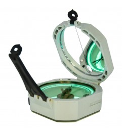
The geological transit you can read in the dark. Illuminated version of the classic Brunton ComPro: one touch lights the azimuth ring, base plate and levels with electroluminescent panels for 60 seconds. ±0.5° accuracy, 150 g...

Most advanced motherboard compass with observation mirror, quick reference cap and protective rubber foot with storage for reference cards with a variety of scales.

If you're looking to save weight in the field, the ultralight ComPro Transit is your mapping solution. Made with all the same internal components, the ComPro is between one ounce and 6 ounces lighter than any other Brunton Transit.
We...

Built with all the functions and features of Brunton , the Standard takes traditional hit and dip measurements and excels at low angle readings with its flat bottom and non-slip silicon foot.

With front and reciprocating bearings, plus 90 ° dials and 6400-point MILS, the compact OMNI-SIGHT compass offers the convenience of...

Prusik pulley with high resistance and high performance

The Latest Forestry Instrument, The Omni-Slope Inclinometer, Measures Angles In Degrees, Percent Of...


 image Featured
Brunton OSS alignment system.
• Declination adjustment without special tools.
• Meridian lines on the map.
• Amplified reading for 1 degree accuracy.
• Protection cover with observation mirror.
• Field reference cards for mapping and emergency use.
• 3 clinometer systems to measure elevation or tilt angles.
• Magnifying glass for maps.
• Chicken eye level.
• Cord included.
• Dimensions: 10.4 cm x 6.3 cm x 2.5 cm.
• Weight: 3.6 oZ
• Resolution of 1 degree.
• Scales: feet, miles and meters. map scale: 1:24 k, utm.
• Made in the USA
| Ref. | Azimuth (0-360ºC) | Quadrant (0-90ºC) |
|---|---|---|
| Scale | 0-360 ° | 0-90 ° |
| Resolution | 1st | |
| Accuracy | 0.5 ° | |
| Dimensions | 10.4 x 6.3 x 2.5 cm | |
| Weight | 102 g | |